Home → Bhutan → Bhutan Trekking → Bhutan Snowland Trekking →
Bhutan Snowland Trekking
lets Know About Bhutan Snowland Trekking
The mix of separation, elevation, remoteness and climate makes this trek an
intense and costly excursion in the entire Himalayas. Charged as the most
troublesome trek on the planet because of height, term and separation,
definitely a bigger number of individuals climb Mount Everest in Nepal than
finishing this elevated journey. Many return inadequate because of elevation
ailment. The trek goes on northern Bhutan along the fringe with Tibet
crossing thirteen Himalayan mountain passes some as high as 5000m. You will
have awesome mountain perspectives on Jumolhari, Jichu Drake, Masangang,
Tiger Mountain and Gangkar Puensum and different prominent tops along the
norther fringe.
If you are intend to this trek, check your crisis departure protection. In
the event that you get into Lunana and snow obstructs the passes, the main
way out is by helicopter, an exorbitant method to complete an effectively
costly trek. Different impediments that frequently hamper this trek are
bridges, in remote districts, that escape by downpours.
The Snowman trek is as often as possible shut in view of day off, is
difficult to embrace during winter. The window for this trek is commonly
viewed as from late September to mid-October; after the primary storm
downpours, however before snow shuts the high passes. Start past the point
of no return and you risk being stuck between two snow-bound passes. Try not
to design a mid year trek; this is a hopeless spot to be during the
rainstorm
You choose your destination and we make sure you to have a great tour. Get a free quote
today or call
+977 9851101623 to know more about tour and Expert packages
Day 01 :Arrival Paro by Druk Air
On landing at Paro you will be met by our representative. After Customs and Immigrations formalities, you will be escorted to the hotel.
Day 02 : Sightseeing at Paro
Drive the winding road northwest up the Pa-Chu to Drukgyel Dzong, the ruined
Fortress which once defended this valley from Tibetan invasion. This Dzong was built
in the 17th century by Shabdrung Nawang Namgyel, the spiritual leader of Bhutan
On a clear day one can view Mt. Jumolhari the sacred Mountain. On the way back we
visit one of the Typical Bhutanese farm house. After lunch at the hotel, we drive to
Ta-Dzong which was once the watch tower for Paro valley, now it houses the National
Museum and then walk down hill pass the Paro Dzong and crossing the typical
traditional roofed bridge to Paro town
Day 03 :Paro – Sharna
It is a short drive of approx 20 minutes up the Paro valley to Drukyel Dzong, which was originally built as a fortress in 1647 to guard against Tibetans invading the Paro Valley. We continue the drive to Shana (1-1.5h drive) from where our trek commences. On this scenic drive we pass through farm country made up of fields of rice, wheat, barley, mustard, potato, and radish as well as herds of cows. The traditional Bhutanese two storey, timber and stone houses can be seen here. We also gain our first views of the summit of Jomolhari (7314m) at the head of the valley.
Day 04 :Sharna – Thangthangka
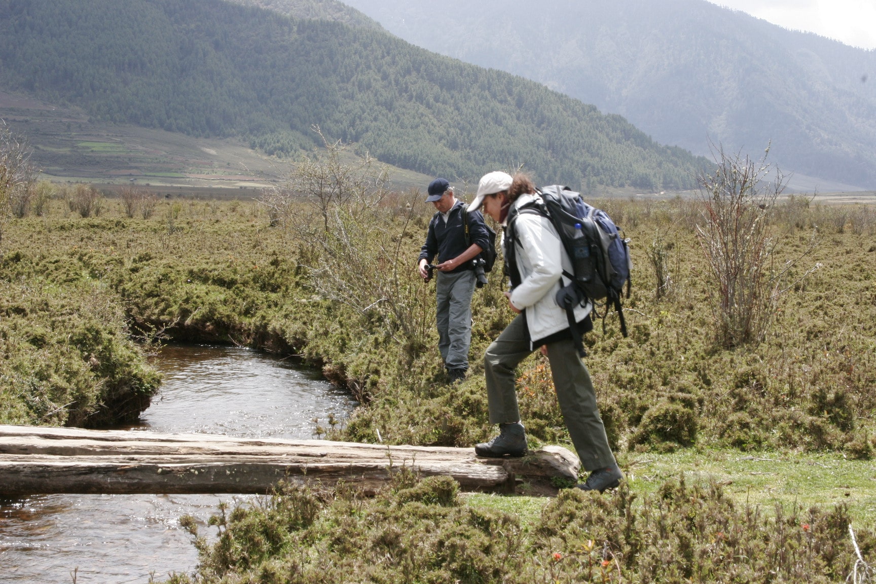
The trail again follows Pachhu (Paro river), ascending and descending through pine, oak and spruce forests. After 2 hours of continuous hiking and crossing several streams, you will reach at Shingkharap, a stone house at 3110m. A hot lunch will be served after crossing the bridge towards the left side of the river. Little ahead is the trail junction – left an old trade route and invasion from Tibet and right leading to the wooden bridge (we follow the right). After climbing up through rhododendron forests and finally crossing the bridge again, we reach our camp at 3750m, which is amidst beautiful meadows.
Day 05 :Thangthangka – Jangothang
An hour out of camp this morning we leave the tree line and head into the high mountains. At the halfway point of our hike, we cross Tengethang, a winter home of the migratory yak herders. Arriving at Jangothang (4040m / 13,250 ft), we can watch the sun set on Mt. Jhomolhari (7314m) and Mt. Jichu Drake (6989m).
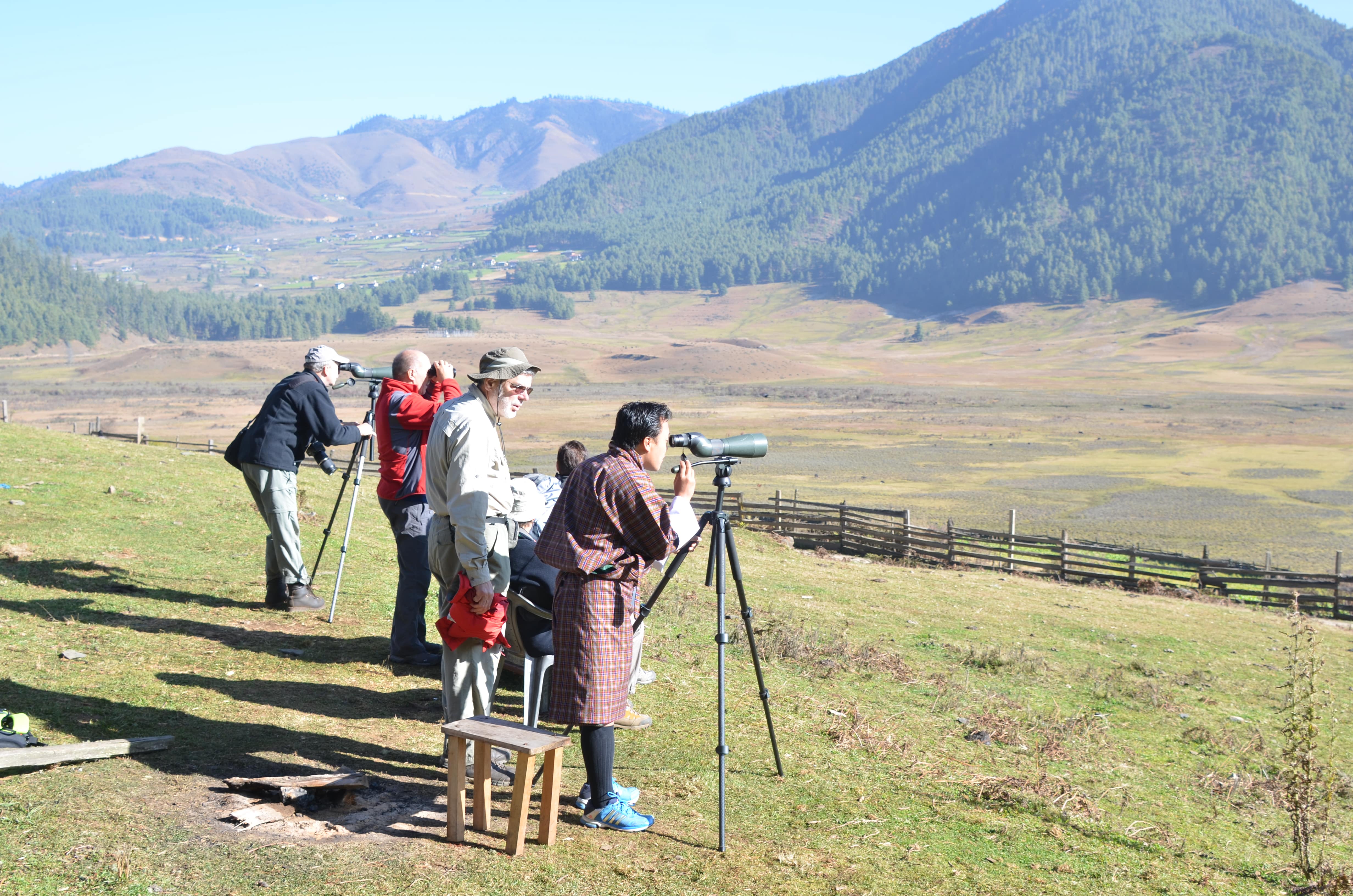
Day 06 : Rest day in Jangothang (Chomolhari Base Camp)
The first of our acclimatization days, we have many day-hiking options. The first is a three to four hour excursion up the ridge to the north for great views of Jichu Drake. The second is to hike up towards the head of the valley in the direction of Jhomolhari. The third is a trek up the main valley towards the last house and onward toward Jichu Drake.
Day 07 :Jangothang to Lingshi | Distance: 20km - 6 to 7 hours
Heading uphill from Jangothang we cross the first of many major passes. The Nyile La pass at 4890m (16,135 ft) is about a four hour ascent. Descending the other side we will encounter sparce juniper and rhododendron and pass many yak herder camps. From this area on we start to see herds of blue sheep. Arriving in Lingshi we set up camp at 4150m (13,700 ft).
Day 08 :Lingshi - Chebisa
Trek Day 6 : Distance 10 km and walking time 5-6 hours. Starting at Lingshi ( 4010m) Trek day 6 is a pleasant walk and you encounter parts of Lingshi village and the settlement of Goyak. On reaching camp at Chebisa village you can visit the village houses.
Day 09 : Chebisa – Shomuthang
Begin trek with a stiff climb up a ridge to Gogu La pass (4,500m) taking nearly four hours. The sights of rare blue sheep is common on the rocks near the top of this pass. After the pass, descend through rhododendron bushes to a lunch stop. Afternoon continue along the trail with intermittent ascents and descents and after crossing the stream, through rhododendron forests and yak herders camp we arrive at Shakepasa at 3980m. From there, we walked down through a thick rhododendron forest until our next camp in Shakshepasa at 3980m.
Day 10 :Shomuthang – Robluthang
Our route takes you directly upwards this morning, traversing grassy slopes and windswept hills to the Jare La. Blue sheep and lammergeirs can often be seen here. Once at the gap, marked by flags and several cairns we can look expansively across to the adjacent valley and our next pass, the Sinche La. The trail winds down through rhododendron, spruce, cypress and birch towards a broad valley floor where yaks may be seen grazing. This may well be our first encounter with the people of Laya whom differentiate themselves by wearing the distinctive woven conical hats with a spike in the top and colourful beads draped around the back.
Day 11 : Robluthang to Limithang | Distance: 19km - 7 to 8 hours
Starting early a strenuous hike leads to the Shinge La pass at 5005m (16,650 ft). Descending to Limithang we’ll see Mt. Gangchenta (6840m) and the glacially carved Gangchhenta valley. Gangchhenta means Great Tiger Mountain. We camp at 4140m (13,650 ft).
Day 12 : Limithang to Laya | Distance: 10km - 4 to 5 hours
A shorter hike follows a trail in and out of a heavily wooded, uninhabited valley. Climbing up out of the forests we will be rewarded with some great views of Gangchhenta and Masang Gang (7165m) mountains. We camp at Laya at 3840m (12,650 ft).
Day 13 : Rest day in Laya
Staying in Laya for the day we will get a chance to see the village with its community school, hospital, archery field and the first shop since the Paro Valley. Laya is a unique village of about 800 people with their own language, customs and distinct dress. The women keep their hair long and wear peculiar conical bamboo hats with a bamboo spike at the top. They wear a lot of silver jewellery on their backs, on many women this display includes an array of teaspoons.
Day 14 : Laya to Rodufu | Distance: 19km - 6 to 7 hours
The trek leads gradually downhill to the Lunana trail junction, then makes a gradual climb to the camp through a forest of conifers, maple and rhododendron. The trail improves and becomes wider as we climb out of the river valley. We camp at Rodufu near a small stream at 4160m (13,645 ft)
Day 15 : Rodufu to Narethang | Distance: 16km - 8 to 9 hours
It is a long hike, first crossing the Tsimo La pass at 4950m (16,200 ft). Descending to Narethang we pass some dwarf rhododendron and hike in the shadow of Gangla Karchung peak (6395m). We camp at 4900m (16,000 ft).
Day 16 : Narethang to Tarina | Distance 18km - 6 to 7 hours
Climb to Karchung La pass at 5240m (17,187 ft) and down to the glacial lakes that are the source of the Tang Chhu river. Above the lakes are the mighty peaks of Jejekangphu Gang (7300m) and Tsenda Kang (7100m). We camp at Tarina, 4020m (13,250 ft).
Day 17 :Tarina to Woche | Distance: 15km - 5 to 6 hours
The walk leads down through conifer forests, following the upper reaches of the Pho Chhu river. The trail then climbs over a ridge and drops to the village of Woche at 3940m (13,000 ft). The trek has now entered the Lunana region. We often continue on about an hour past Woche to a spectacular campsite below the Keche La pass.
Day 18 : Woche to Lhedi | Distance: 19km - 7 to 8 hours
It’s a gradual climb from Woche to the campsite below the pass, and then gets steeper on the section up to the Keche La, at 4580m (15,100 ft), after which it drops steeply to Thega village our usual lunch spot. The afternoon hike continues along a beautiful river valley past spectacular waterfalls to Lhedi village where we camp at 3600m (11,800 ft). Sometimes we continue on about an hour or so beyond Lhedi village to a lovely campsite.
Day 19 :Lhedi to Thanza | Distance: 19km - 6 to 7 hours
The trail climbs gradually following the main source of the Pho Chhu to Chozo village. At the small Chozo Dzong there are some lay monks. Above Chozo the valley opens as we approach Thanza village near the foot of 7100m Zogophu Gamp, which is also know as Table Mountain. We camp at Thanza, 4080m (13,300 ft).
Rest Day In Thanza, 4080m (13,300 ft)
This day is a fantastic opportunity to interact with the hospitable local villagers, and explore the beautiful surrounding area, our farthest point in the Lunana valley. Alternatively you can relax around camp and rest up for some of the tough days ahead. As Thanza is sometimes a transfer point for horses and yaks, it is sometimes necessary to have a day here for our staff to ensure all the necessary yaks are rounded up by the local herders who do not operate on 'Western time'! Please note: Assuming everyone in the trekking party has acclimatized properly up to this point, and our horse/yak logistics are smoothly in place, we may only spend the morning in Thanza, and leave for our campsite up the valley at Danji in the afternoon in order to save the rest day in case it is required later in the trek due to altitude or weather-related concerns while crossing the Rinchen Zoe pass out of Lunana.
Day 21 :Thanza - Tshochena
Trek Day 19 : Distance 20 km and walking time 7-8 hours We start early from Thanza to the base of Taze-la pass. Then trek to Jaze-la pass at 5050m and downhill until we reach the camp site.
Day 22 :Tshochena - Jichu Dramo
Trek Day 20 : Distance 14 km and walking time 4-5 hours. Today the trail raises and falls at regular intervals as we trek between the snow capped peaks and cross Loju-la pass at 4940m. We camp at Jichu Dramo
Day 23 :Jichu Dramo - Chukarpo
Trek Day 21 : Distance 18 km and about 5-6 hours. Starting from Jichu Dramo, we trek to Gang Rinchen-zoe la pass at 5140m and then its all the way down hill till you reach Chukarpo.
Day 24 :Chukarpo - Thampe Tsho
Trek Day 22 : Distance 18 km and walking time 5-6 hours Starting from Chukarpo its mostly downhill till Um Tsho (lake) 4230m. This is where a lot of religious treasures were discovered. The camp is is bit further at Thampe Tsho.
Day 25 :Thampe Tsho - Maurothang
Trek Day 23 : Distance 14 km and walking time 5 hours.
Starting at Thampe Tsho, the day's trek starts with a couple of hours walk to the
base of Tampela and then on to the Tampela pass at 4580m. From here the trek goes
all the way down hill through Rhododendron bushes till you reach a yak pastures. Day
26 Maurothang - Nikachu
Trek Day 24 End of Trek : Distance 18 km and walking time 5-6 hours
Today is your last day of trek. The trail passes through bamboo thickets and fields
following the Nikachu river and ends at the village of Sephu at 2500m by the Nikachu
bridge. From here you can either drive to Trongsa (2hours) and then continue
sightseeing of Trongsa and Bumthang , this will extend your itinerary by 3 more days
or drive from Nikachu towards Thimphu. Night halt at Wangdue Phodrang.
Day 26 :Wangdue Phodrang - Thimphu
Morning rest or visit Chhimi Lhakhang in Punakha and sightseeing of Punakha town. Afternoon drive to Thimphu
Day 27 :Thimphu Sightseeing
After breakfast we visit the National Memorial Chorten, built in memory of the late King. We also visit the Handicraft Emporium/Chokey handicraft and the National Painting School. After lunch we shall visit Simtokha Dzong and explore Thimphu town. If the day falls on a Saturday or Sunday then visit the weekend market.
Day 28 :Thimphu - Paro
Continue sightseeing of Thimphu and afternoon to Paro (2 hours).
Day 29 :Farewells and departure
Company & Services :
Subscribe
Be the first to know about the new trip.